2.3 Additional Questions :
Answer the following questions :
1. What is an atlas?
Ans: One map shows a small area and and a few facts. Another map may contain as many facts as a big book. When many maps are put together we get an Atlas.
2. What are the 3 types of maps. Explain each briefly.
Ans: The three types of maps are :
i) Physical maps: Maps showing natural features of the earth such as mountains ,plateaus ,plains ,rivers ,oceans ,etc. are called physical or relief maps.
ii) Political maps: Maps showing cities, towns and villages, and different countries and states of the world with their boundaries are called political maps
iii)Thematic maps: Some maps focus on specific information such as road maps, rainfall maps, maps showing distribution of forests, industries, etc .are known as thematic maps.
3. What do you mean by scale of a map .Explain with one example.
Ans: Scale is the ratio between the actual distance on the ground and the distance shown on the map.
For example ,the distance between your school and your home is 10 km. If you show this 10km .distance by 2 cm on a map , it means 1 cm on the map will show 5cm on the ground . The scale of your drawing will be 1cm = 5km.
4. What is large scale map and small scale map . Explain by giving simple examples.
Ans:
i) When large areas like continents or countries are to be shown on a paper ,then we use a small scale . For example 5cm . On the map shows 500km of the ground. It is called a small scale map.
ii)When a small area like your village or town is to be shown on paper,then we use a large scale that is 5cm. On the map shows 500 meters only on the ground. It is called a large scale map.
5. What is North line?
Ans: Most maps contain an arrow marked with the letter ‘N’ at the upper right hand corner . This arrow shows the northern direction .It is called the North line.
6. What is a compass? What is its use? Draw and explain.
Ans: We can find out the direction of a place with the help of a compass. It is an instrument used to find out main directions . Its magnetic needle always points towards north- south direction .The point of the arrow marked in red always points towards the north.
7. What are conventional symbols. Draw some of them.
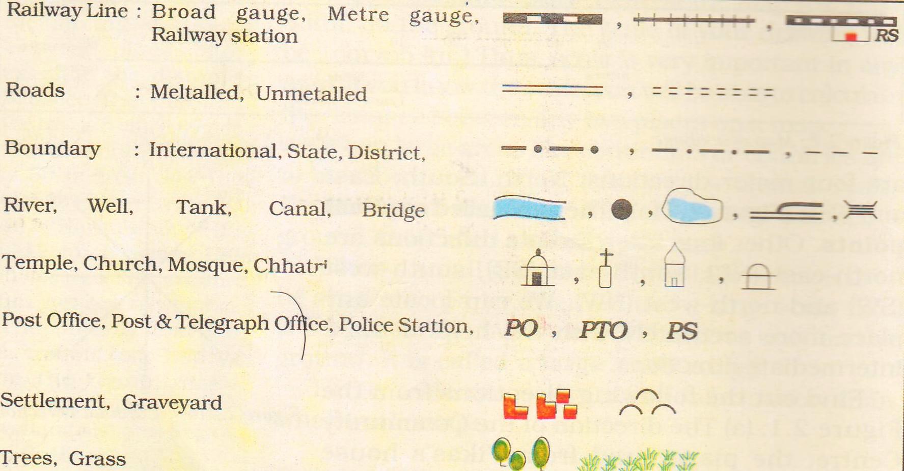
Ans: It is the third important component of a map. You can collect information from maps with the help of these symbols. Maps have a universal language that can be understood by all. There is an international agreement regarding the use of these symbols. These are called conventional symbols. Some of the conventional symbols are shown:
8. What is a sketch map?
Ans: A rough drawing drawn without scale is called a sketch map.